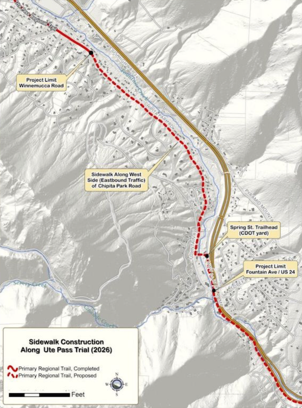
A new trailhead and Ring the Peak portal are coming to Cascade this fall, and it’s more than a ribbon-cutting — it’s the missing link that turns a patchwork of trails into a real regional asset.
Jeremy Jones reported for Springsmag on September eighth that El Paso County Parks is building a one-point-five-mile paved and gravel extension from the Fountain Avenue and Highway twenty-four intersection in Cascade to the existing Teller County trail at Winnemucca Road. The project includes a new trailhead and an official Ring the Peak portal, funded in part by a four-hundred-thousand-dollar grant from Pikes Peak Outdoors. It’s on schedule for December completion.
That matters because Ring the Peak has been a twenty-year vision — a roughly fifty-mile loop around Pikes Peak connecting communities from Manitou Springs through Cascade, Green Mountain Falls, and into Teller County. For decades, a blank spot on the map between Manitou and Green Mountain Falls kept it from being a true loop. This segment closes that gap.
What a completed Ring the Peak delivers to the region:
- A continuous, multi-day hiking and biking route that draws visitors beyond a single-day trip to the summit
- Trail access that links neighborhoods, schools, and businesses along Ute Pass instead of forcing people onto Highway twenty-four
- A shared identity for the Pikes Peak region — one trail that tells the story of the mountain from every side
- Economic lift for towns like Cascade, Chipita Park, and Woodland Park as through-traffic becomes trail traffic
The hard part isn’t done. Jason Meyer, El Paso County’s park planning division manager, noted the final stretch — crossing Fountain Creek on Colorado Springs Utilities watershed property inside CDOT right-of-way — still needs partnerships to finish. But the Cascade-to-Winnemucca piece is the one that makes the loop feel real.
Full story from Jeremy Jones at Springsmag: https://springsmag.com/ute-pass-regional-trail-extension-on-track-to–this-fall/